August 2026: A Tale of Two (or Three or Four or more) Lakes
I have a woodcut plaque of Lake Katherine on the wall just above where I sit at my home computer. It is a cherished gift from a few years back from one of my adult children. From time to time, I gaze at it and contemplate the geological forces that created the lake and how it came to have such a complex shape, several lakes within a lake it almost seems.
We know that the last glacial period created the modern landscape of northern Wisconsin including the lakes. What is called the Laurentide Ice Sheet began its advance into Wisconsin from the north around 31,500 years ago, expanding southward over the next 13,500 years. Ice was thousands of feet thick in the center of the sheet. The ice melted over the next ten thousand plus years, fully disappearing about 11,000 years ago. Lakes were formed as large blocks of ice covered by windswept soil melted.
What is Lake Katherine today may have looked quite different when it first appeared. Nearby lakes could have been connected during high water years and the lake could have been separated into as many as four lakes during exceptionally low water periods. There is no evidence to be found that today's lake was two, three, or four lakes for any long period of time, but the contours of the lake bottom make it clear that there are four separate “basins” connected to each other by relatively narrow and shallow areas.
There are no formal names for the four basins of Lake Katherine, but several have common names used by longtime lake residents. Some of these can be seen in the Lake Katherine Association directory. The smallest basin is called South Bay. It lies on the west side of Highway 51 as one crosses under the Lake Katherine bridge. South Bay is about 25 acres and gets to a depth of 25 feet in the middle. Much of the shoreline is steep with the lake depth dropping off quickly from the shoreline. Despite the height and steepness of land on the west end of the bay, that area is quite shallow because the steep hill separating it from Lee Lake is a man-made marvel created over a hundred years ago by the strong backs of men and machines so that a railroad line could pass through. Were it not there, a marsh would likely connect the two lakes. On the other end of South Bay’s northern shore is what is popularly known as “The Wayside” a former but now abandoned official highway wayside owned and operated by the Wisconsin Department of Transportation. While abandoned, it remains open and maintained by frequent use, primarily by kayakers launching their watercraft, fishermen casting a line from shore, people who like to fish through ice in winter, and walkers of the trail through the Yawkey Forest Reserve parcel to the Bearskin Trail. The narrow and shallow channel on the east side of the bay that goes under the bridge connects it to the vee-shaped Indian Bay, Tigertail Point, the piece of land protruding south and creating the vee shape.
On maps of Lake Katherine, Indian Bay typically refers to the eastern part of the vee, the shorter western part sometimes called “the Narrows.” Both parts have steep dropoffs from shore along much of the shoreline, but much like the west end of South Bay, the east end of Indian Bay is shallow, and at one time before the construction of South Shore Drive. connected to a forested bog that shows up a little later in this tale. The total surface water acreage of these two stretches of this basin is about 100 acres with a maximum depth of 25 feet in two small places in Indian Bay. There is an underwater narrow linear rocky shoal that stretches from just north of Pink Island to the point about halfway down that eastern shoreline. Fishermen are well aware of this unusual feature. Large fish preferring deeper and colder water can sometimes be caught by a lure or a minnow or nightcrawler on a hook cast outward from the shoal and worked upward to its top. Pink Island at the tip of Tigertail Point is connected underwater to the mainland by a shallow sandbar. In most years, small boats can pass over the sandbar. During extreme drought periods like existed in the late 2020-aughts to about 2010, the sandbar can be knee deep or even above water. Pink Island along with Chase Island to the south near the Lake Katherine bridge are part of the Yawkey Forest Reserve owned and managed by the Northwoods Land Trust. Pink Island has from time to time hosted a loon nest and is considered a place requiring protection for bird life, thus the signs requesting no public use of the island. Indian Bay has another unusual feature, several small wetlands on land above the shoreline. These “perched” wetlands on parcels that are part of the Yawkey Forest Reserve are likely there because of springs. A beaver colony has built its lodge along the shoreline between a perched bog and a perched swamp. For now, the beavers are obtaining much of their food from the trees they cut down in the swamp.
The eastern side of the vee - “The Narrows” - also has a rocky shoal, but much smaller. During low water summers, one can see (and hopefully avoid if in a motorboat) the tip of the shoal protruding above water, occasionally festooned with a couple of man-made objects either as a warning of shallow water or just for fun. The steep slopes of Tigertail Point on the east and similarly steep slopes on the west create the common dropoffs into deep water. Just a few yards inland from the eastern shoreline are the remnants of the railroad line built and owned by the Yawkey Lumber Company to get logs from surrounding forests to the mill, which was at the current location of the Town Hall and Town Park.
“The Narrows” narrows down between two small peninsulas, the one on the east including a small island at the tip called “Beaver Island.” That island, privately owned, is connected to the peninsula by a very shallow rocky stretch that in most years is barely passable by a kayak. The depth of water between the two peninsulas is around six feet, but drops off quickly as one enters the largest basin of the lake. “North Bay” appears on local maps, but typically refers to the very north end of Lake Katherine. The entire basin (let’s call it “North Basin”) itself is about 350 acres. The maximum depth in the North Basin is 30 feet in two small areas. There are four islands. Crescent Island is privately owned and the only island on the lake with a residence. It has a long shoal off its northwestern corner. Adjidaumo Island is also privately owned. It has hosted an eagle nest for many years. George Island is part of the Yawkey Forest Reserve. Nearby tiny Baby Leigh Island (aka Penny Island) is owned by the Wisconsin Department of Natural Resources. In recent years it has been the preferred nesting spot by out one territorial pair of loons.
The steepness of the shoreline varies in the North Basin. Slopes are gentle along the eastern shoreline and steep on most of the northern, eastern, and southern shorelines. The eastern shoreline is part of the Yawkey Forest Reserve. Like part of the eastern shoreline of Indian Bay, it has very small perched wetlands, but these have been dry in recent years. Between Adjidaumo Island and the northern shoreline is another long and narrow rocky shoal, this one stretching from the northern tip of the island to the mainland. The water depth over the shoal varies with lake level, but it is often only three or four feet deep. A slightly deeper area between the end of the shoal and the mainland allows motorboats to pass through safely.
North Bay has the two wetlands tucked in the northwesternmost corner of the lake. Both are small forested bogs that grade into shallow coves filled with aquatic rooted plants like water lilies. These wetlands are important nutrient providers as well as good habitat for herons and certain kinds of fish. Regrettably, both have significant mats of aquatic forget-me-not that is an aquatic invasive species that the State has now declared naturalized because it is so widespread.
At the east end of the North Basin is another narrowing of the lake and a shallow channel leading to Tomahawk Bay, the fourth basin of the lake. It’s about 50 acres with relatively steep slopes and associated rapid dropoffs. Its maximum depth is a very small area of 25 feet. Like South Bay, recent human history has affected its current condition. In 1893, the state legislature approved construction of a canal between Lake Katherine and Lake Tomahawk at the northeast corner of Tomahawk Bay for the express purpose of transporting logs to the Yawkey Lumber Company mill on Lake Katherine. The canal was dug and over time a concrete dam was constructed at the Lake Katherine end of the canal. One can see the sides of the dam there and an adventurous soul can paddle a kayak, paddleboard, or canoe through the canal to Dollar Lake and to the small dam on the other end entering Lake Tomahawk.
To this point in the tale, there has been no mention of inlets or outlets in the other three basins. Like many glacial lakes of the Northwoods, Lake Katherine is not part of a chain of lakes associated with a river system and is for the most part a self-enclosed lake system without river or stream inlets or outlets - except one, and that one is poorly known. The southeast side of Tomahawk Bay merges into an 80 acre bog complex to the east. And in the middle of that bog is a three acre bog pond, a common feature of many large bogs in the northern latitudes. If one looks carefully at the Tomahawk Bay shoreline in the cove where the bog starts, there can be seen a tiny stream carrying water moving from the bog pond to the lake, the only inlet to Lake Katherine. The bog pond carries no formal name on topographic maps, but a 1973 map of uncertain origin identifies it as Fabian Lake. In terms of the watershed of Lake Katherine, the bog and bog pond are part of it, a fifth “basin” of sorts with an interesting tale to be written later.
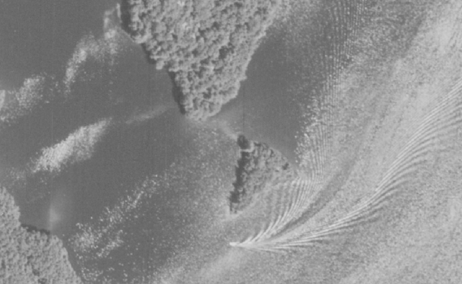
1960 image of a boat going around Pink Island at the end of Tigertail Point and heading into the Narrows. Note the sandbar between the island and the point and the small rocky shoal off the western shoreline. Photo courtesy of University of Wisconsin digital archives.